Offering Details
Back
Under Review / Baserado Resources Ltd.
Baserado Resources Ltd.
Bid Deadline: February 19, 2026
12:00 PM
Download Full PDF - Printable
OVERVIEW
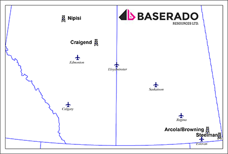
Baserado Resources Ltd. (“Baserado” or the “Company”) has engaged Sayer Energy Advisors to assist the Company with the joint venture, farmout, or sale of its mineral interests located in the Nipisi and Craigend areas of Alberta, and the Arcola/Browning and Steelman areas of southeastern Saskatchewan (the “Properties”).
The Properties consist of predominantly 100% working interests in Crown and Freehold mineral rights with prospective drilling locations for oil and natural gas.
At Steelman, Baserado has a 100% working interest in 1.25 sections of land with P&NG rights from the base of the Midale zone to the top of the Precambrian.
At Arcola/Browning, Baserado has a 100% working interest in 1.5 sections of land. At Arcola, the Company has mineral rights from the surface to the top of the Precambrian in two quarter sections and at Browning, from surface to the top of the Precambrian in four quarter sections.
At Craigend, Baserado has a 100% working interest in 1 section of oil sands rights from the top of the Viking Formation to the base of the Woodbend Group.
At Nipisi, Baserado has a 100% working interest in 2 sections of land with P&NG rights from the base of the Bluesky-Bullhead Formation to basement in one section and base of the Spirit River Group to basement in the other section.
Further details of the Properties will be available in the virtual data room for parties that execute a confidentiality agreement.
Overview Map Showing the Location of the Divestiture Properties
Liability Assessment Summary
Baserado does not own an interest in any wells or facilities.
Seismic Overview
The Company does not have ownership in any seismic data relating to the Properties.
Reserves Overview
Baserado does not have a third-party reserve report.
Baserado does not own an interest in any wells or facilities.
Seismic Overview
The Company does not have ownership in any seismic data relating to the Properties.
Reserves Overview
Baserado does not have a third-party reserve report.
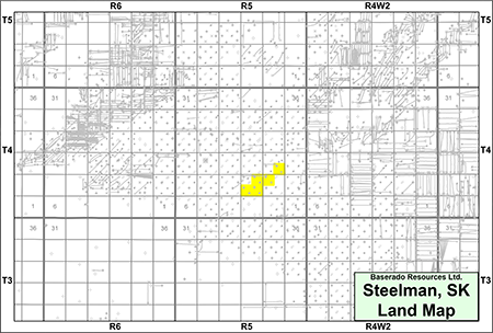
STEELMAN
Township 4, Range 5 W2
At Steelman, Baserado has a 100% working interest in 1.25 sections of land with P&NG rights from the base of the Midale zone to the top of the Precambrian.
The Steelman property is prospective for light oil in the Frobisher Formation.
At Steelman, Baserado has a 100% working interest in 1.25 sections of land with P&NG rights from the base of the Midale zone to the top of the Precambrian.
The Steelman property is prospective for light oil in the Frobisher Formation.
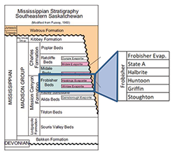
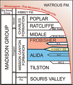
Frobisher Formation
The Frobisher Formation at Steelman consists of a series of southwest-northeast trending carbonate shoals. Development of the Frobisher has primarily taken place along structural highs identified along the regional Frobisher/Midale Ridges, which coincide with the development of these shoals. While historical vertical production focused on the porous intervals of the Lower Halbrite and Huntoon formations, recent horizontal drilling has targeted the State A and Upper Halbrite Frobisher zones, which are shown in the following well logs. These zones generally exhibit lower permeability and have been overlooked in traditional vertical development.
The Frobisher Formation at Steelman consists of a series of southwest-northeast trending carbonate shoals. Development of the Frobisher has primarily taken place along structural highs identified along the regional Frobisher/Midale Ridges, which coincide with the development of these shoals. While historical vertical production focused on the porous intervals of the Lower Halbrite and Huntoon formations, recent horizontal drilling has targeted the State A and Upper Halbrite Frobisher zones, which are shown in the following well logs. These zones generally exhibit lower permeability and have been overlooked in traditional vertical development.
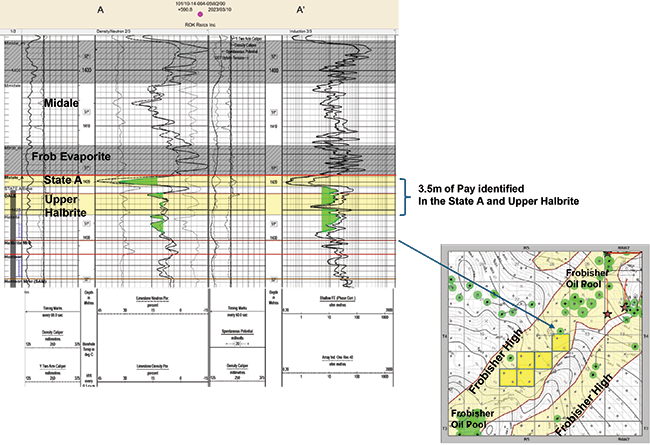
The Company has identified up to 8 multi-leg 1-mile horizontal drilling locations and 4 additional half-mile multi-leg locations targeting the State A and Halbrite zones on its lands at Steelman.
Successful Frobisher development has occurred offsetting the Company’s lands by ROK Resources Inc., Tetonka Resources Inc., and Tundra Oil & Gas Limited as well as recent land sale activity by Whitecap Resources Inc.
Successful Frobisher development has occurred offsetting the Company’s lands by ROK Resources Inc., Tetonka Resources Inc., and Tundra Oil & Gas Limited as well as recent land sale activity by Whitecap Resources Inc.
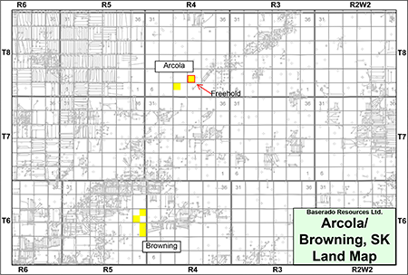
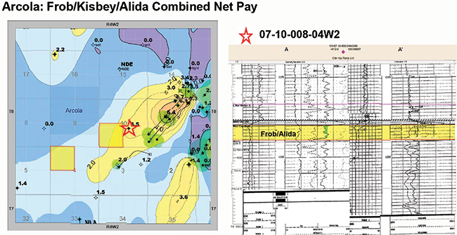
ARCOLA/BROWNING
Township 6-8, Range 4-5 W2
At Arcola/Browning, Baserado has a 100% working interest in 1.5 sections of land. At Arcola, the Company has mineral rights from the surface to the top of the Precambrian in two quarter sections and at Browning, from surface to the top of the Precambrian in four quarter sections.
At Arcola, the Company has identified potential for drilling in the Frobisher, Alida and Kisbey formations.
At Browning, the Company has identified multi-zone horizontal drilling potential within the Frobisher Formation.
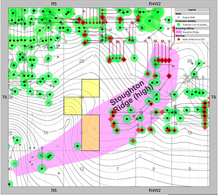
At Browning, the Company has identified bypassed pay in the Frobisher Beds. The area has been an active area for Frobisher horizontal development since 2021. Successful Frobisher development has occurred directly offsetting the Company’s lands by Saturn Oil & Gas Inc., Triland Energy Inc., Vital Energy Inc., West Lake Energy Corp. and Whitecap.
The Company has structural mapping over the Property which shows a robust ridge (structural high) trending through the offset Frobisher development as shown on the following map.
Bypass pay is identified in the 101/09-13-006-05W2/0 well, supported by a DST show and oil charged reservoir identified in core and logs.
The proposed location would target the Upper Stoughton (K1) interval with the initial well oriented in an up-dip direction from the 9-13 well. A potential second leg would target the Upper Stoughton interval approximately 2-3 metres lower than the first leg. A third leg could be considered for further development in the Griffin if the formation shows reservoir potential while drilling the build section.
The proposed location would target the Upper Stoughton (K1) interval with the initial well oriented in an up-dip direction from the 9-13 well. A potential second leg would target the Upper Stoughton interval approximately 2-3 metres lower than the first leg. A third leg could be considered for further development in the Griffin if the formation shows reservoir potential while drilling the build section.
Kissinger ALMX LBTY Brown'g 101/09-13-006-05W2/0
Frobisher Formation Type Log
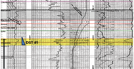
Frobisher Formation Type Log
At Arcola, the Company has identified potential for drilling in the Frobisher, Alida and Kisbey formations.
Recent successful Frobisher development by Triland directly offsets the Company’s lands at Arcola.
Baserado’s prospect is analogous to the Wordsworth pool to the south and on trend with the western ridge of the Arcola south pool.
Baserado’s prospect is analogous to the Wordsworth pool to the south and on trend with the western ridge of the Arcola south pool.
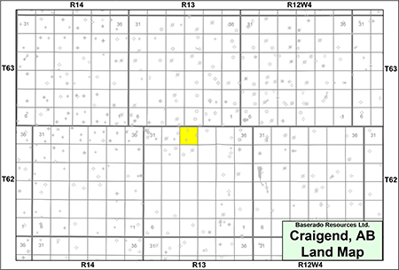
CRAIGEND
Township 62, Range 13 W4
At Craigend, Baserado has a 100% working interest in 1 section of oil sands rights from the top of the Viking Formation to the base of the Woodbend Group.
The Craigend property is prospective for heavy oil in the Clearwater Formation.
At Craigend, Baserado has a 100% working interest in 1 section of oil sands rights from the top of the Viking Formation to the base of the Woodbend Group.
The Craigend property is prospective for heavy oil in the Clearwater Formation.
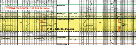
Clearwater Formation
There have been recent large Crown oil sands purchases offsetting the Company’s lands by Lineup Resources Corp. and Rubellite Energy Inc.
There have been recent large Crown oil sands purchases offsetting the Company’s lands by Lineup Resources Corp. and Rubellite Energy Inc.
Evidence of oil production at 100/14-19-062-12W4 shows viscosity of approximately 10,000 cP at 25°C.
The following well log shows the Clearwater lower sand reservoir at Craigend with the following parameters: Average porosity thickness of 27%, average water saturation of 32%, oil originally in place of approximately 6.1 MMbbl, with estimated ultimate recovery of 310,000 bbls of oil at a 5% recovery factor.
The following well log shows the Clearwater lower sand reservoir at Craigend with the following parameters: Average porosity thickness of 27%, average water saturation of 32%, oil originally in place of approximately 6.1 MMbbl, with estimated ultimate recovery of 310,000 bbls of oil at a 5% recovery factor.
CNRL Craignd 100/09-33-062-13W4/0
Clearwater Formation Type Log
Clearwater Formation Type Log
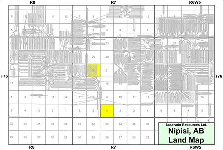
NIPISI
Township 76, Range 7 W5
At Nipisi, Baserado has a 100% working interest in 2 sections of land with P&NG rights from the base of the Bluesky-Bullhead Formation to basement in one section and base of the Spirit River Group to basement in the other section.
The Nipisi property is prospective for heavy oil in the Banff Formation.
Banff Formation
During the Mississippian, the depositional environment was established with regional extension creating localized structural relief through normal faulting, establishing focused deposition of discrete carbonate buildups with locally excellent reservoir quality. The Banff reservoir at Nipisi is interpreted as Waulsortian-style mudmounds rather than classical Banff shelf facies.
Drilling across multiple areas has demonstrated that Waulsortian mudmounds can form thick carbonate, laterally confined reservoirs with a wide porosity range. These favorably positioned mudmounds have supported commercial oil accumulations.
The following well log shows the Banff reservoir at Nipisi. The reservoir is found at depths of approximately 775 metres and with average porosity between 6-25%, average permeability estimated between 100-1,000 mD with approximately 20% average water saturation. The oil is estimated to be 12°API.
Journey Energy Nipisi 100/05-29-076-07W5/0
Banff Formation Type Log
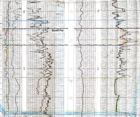
Banff Formation Type Log
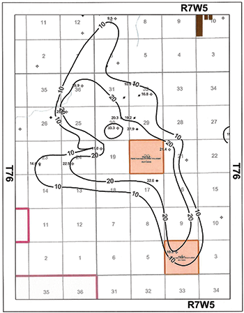
Found below is an isopach map of the Banff at Nipisi.
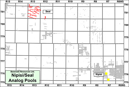
An analogue to the Banff mudmounds at Nipisi is the Seal field where Waulsortian mudmounds are being developed by Islander Oil & Gas Inc. While referred to as Pekisko in that area, these mudmounds represent the same facies as the Banff reservoir at Nipisi.
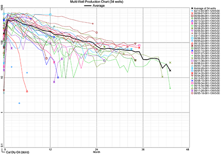
The following production plot shows the recent Islander oil wells at Seal.

The following multi-well production plot shows the low decline of the recent Islander oil wells at Seal.
PROCESS & TIMELINE
Sayer Energy Advisors is accepting proposals relating to this process until 12:00 pm on Thursday February 19, 2026.
Sayer Energy Advisors does not conduct a "second-round" bidding process; the intention is to attempt to conclude
transaction(s) with the party(ies) submitting the most acceptable proposal(s) at the conclusion of the process.
transaction(s) with the party(ies) submitting the most acceptable proposal(s) at the conclusion of the process.
Sayer Energy Advisors is accepting proposals from interested parties until
noon on Thursday February 19, 2026.
NOTE REGARDING A SAYER PROCESS
On each and every offering brochure generated by Sayer, you will note the sentence “Sayer Energy Advisors does not conduct a “second-round” bidding process; the intention is to attempt to conclude a sale of the Properties with the party submitting the most acceptable proposal at the conclusion of the process.” What this means is that Sayer will not go back to multiple parties at the same time after bids are received, asking them all for a second bid. We determine which party submitted the most acceptable proposal and then we attempt to negotiate acceptable terms with that party in a “one-off” situation.
If the process involves a cash sale of a property or company and the party which submitted the most acceptable proposal has met our client’s threshold value, that offer will be accepted. If this proposal does not meet our client’s threshold value, then we will advise that party that the offer is not quite what our client was expecting, and we will ask them to increase the offer. If that offer is not acceptable to our client, we will then move down to the party which submitted the next most acceptable proposal and we will then work with that party to attempt to meet our client’s threshold value.
In the extremely rare circumstance where two or more parties submit virtually identical proposals, we will contact all parties, we will advise them of this situation and we will ask them to submit a revised proposal. Once these are received, we will work with the party which has submitted the most acceptable proposal.If the process involves a cash sale of a property or company and the party which submitted the most acceptable proposal has met our client’s threshold value, that offer will be accepted. If this proposal does not meet our client’s threshold value, then we will advise that party that the offer is not quite what our client was expecting, and we will ask them to increase the offer. If that offer is not acceptable to our client, we will then move down to the party which submitted the next most acceptable proposal and we will then work with that party to attempt to meet our client’s threshold value.
CONFIDENTIALITY AGREEMENT
Parties wishing to receive access to the confidential information with detailed technical information relating to this opportunity should execute the Confidentiality Agreement and return one copy to Sayer Energy Advisors by courier, email (brye@sayeradvisors.com) or fax (403.266.4467).
Included in the confidential information is the following: mineral property reports, geological presentations and other relevant technical information.
Download Confidentiality Agreement
To receive further information on the Properties please contact Ben Rye, Tom Pavic or Sydney Birkett at 403.266.6133.